If you would like to get in touch, please feel free to contact: email hidden; JavaScript is required
Browse collection
- Full collection
- 18th Century & earlier
- Ackermann
- Africa
- Alken
- Animals
- Arabasia
- Architecture/Mansions
- Art
- Australasia
- Botany
- British Isles
- Caricatures
- Children
- China
- Chromo added colour
- Chromolithographs
- Conchology
- Costume
- Cruikshank
- Culture/Lifestyle
- Dutch
- East European
- Far East
- France
- Furniture/Antiques
- General
- Germany
- Grandville
- Heraldry
- History
- History - England
- History - Europe
- Holy Land
- India
- India - sepia
- Islam
- Italy
- Japan
- Literature
- London
- Manuscript
- Map
- Military
- Monnier
- Natural history
- Pastimes
- Pochoir
- Polar regions
- Portraits
- Religious/Christian
- Religious/other
- Rowlandson
- Russia
- Science
- Scrapbook
- Sepia
- South America
- Sports/Hunting
- Stamps
- Swiss
- The Americas
- Theatre
- Travel/Scenery
- Watercolours
- World
BAERLE, Caspar van - [BARLAEUS].
Rerum per Octennium in Brasilia et alibi nuper gestarum sub Praefectura Illustriani cometis J. Mauritii Nassoviae etc. … Historia. [Events which recently took place in Brazil and elsewhere over an eight year period.]


- Published
- Amsterdam: Johannes Blaeu, 1647.
- References
- Borba de Moraes I, 78-79; European Americana 647/9; Sabin 3408; Bobins 802.
- Plates
- 59
- Binding/Size
- L=FOLIO
- Value
- 100001-1m
- Published
- Amsterdam: Johannes Blaeu, 1647.
- Ref
- 5572
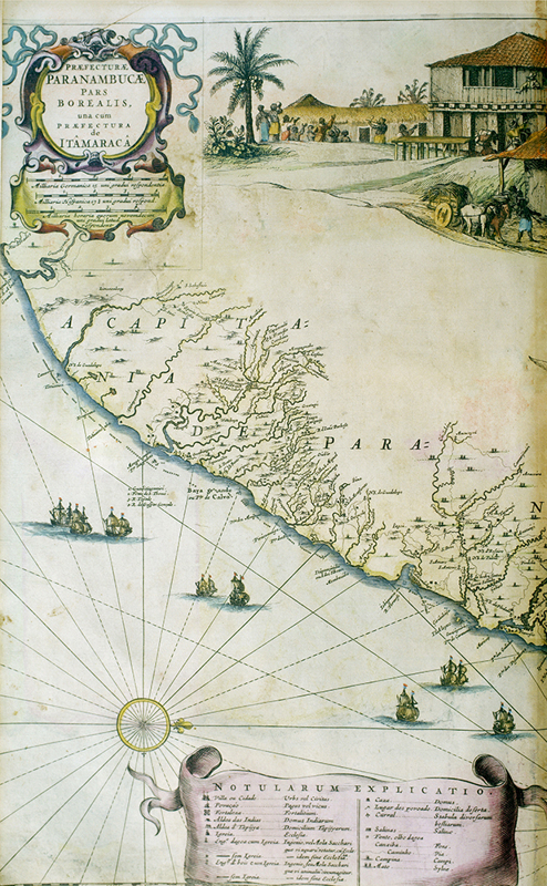
FIRST EDITION. Folio, printed title with woodcut publishers logo, engraved pictorial title, etched portrait of Maurice of Nassau, finely hand- coloured. 56 large etched, numbered plates and maps, double-page and mounted on guards, plates by Thos. Matham. Large folding views of Recife and S. Paolo de Loana, and an unnumbered double-page map of Chile; some maps with elaborate vignette cartouches showing scenes of native life, compass rose, and ships. The frontispiece, portrait, title page vignette, and other details are heightened in gold, hand-coloured double-page portrait map, details hand-coloured. It is extremely rare to find this work complete and finely hand-coloured and embellished with gold by a contemporary hand. Contemporary paneled calf gilt, spine gilt in compartments, Carthusian arms on sides. Many plates and text with water stains etc. Only a very small number are known to have been coloured at the time of publication, and this colouring must be considered of extremely high quality. The Governor of the Dutch Colony commissioned the work at Pernambuco, Johan Mauritz van Nassau-Sieges, a remarkable man, not only a military leader but also well versed in the arts. He persuaded a group of artists and craftsmen to leave the Netherlands for New Holland, amongst them Frans Post (1612-1680), a gifted landscape artist who came to be known as “the Canaletto of Brazil.” His engravings were incorporated into the present work, which describes Johan Mauritz’s reign in Brazil and the country and its inhabitants. This work and this copy must attract superlatives. **Edited by Johannes Blaeu, the work is of great topographical significance and the finest early pictorial record of Brazil.** Coloured plates in order: 1. Title page vignette. 2. Dedication. 3. Portrait of Joannis Mauritii. 4. [Map] Preafecturae de Ciriii vel Seregippe del Rey cum Itapuama. 5. [Map] Praefecturae Paranambuca pars Borealis uns cum Praefecturae de Itamaraca. 6. [Map] Preafecturae Paranambuca pars Meridionalis. 7. [Map] Preafecturae de Paraiba, et Rio Grande. 8. Classis Navium qua hinc discessit comes Mauritius Praefectus. ( Dutch ships). 9. Praelium Propeportum Calvum. (View of a Battle). 10. [Plan] Portus Calvus. 11. Obsidio et Expugnatio Portus Calvi. (Settlement). 12. [Plan] Civitas Olinda. 13. Olinda (view). 14. Garasu (view). 15. Serinhaim (view). 16. [Plan] Civitas Formosa Serinhaemensis. 17. [Plan] Pargus Alagoae Australis. 18. Alagoa ad Austrum (view). 19. [Map] Castrum Mauritij. 20. castrum Mauritij ad Ripam Fluminis S. Francisci (view). 21. I. Maraca (view). 22. [Map] Insula Tamaraca. 23. [Plan] Castrum Mina. 24. Castrum Minae (View). 25. [Plan] Arx Nassouij. 26. Arx Nassouii (view). 27. Siara (view). 28. [Plan] Arx In Siara. 29. [Plan] Frederica Civitas. 30. Parayba (view). 31. Ostium Fluminis Paraybae (view). 32. [Map] Castrum Ceulianum. 33. Fluvius Grandis (view). 34. Sinus Omnium Sanctoru (view). 35. [Map] Sinus Omnium Sanctoru, with inset map of Civets San Salvatoris. 36. [Map] Insula Antonij Vaazij. 37. Arx Principis Guilielmi (view). 38. Mauritiopolis (large panoramic view). 39. [Map] Loca Paludosa et Sylvestria. 40. S. Augustini (view). 41. Friburgum (view). 42. [Plan] Friburgum. 43. [Map] Mauritiopolis Reciffa et Circumiacentia Castra. 44. Boa Vista (view). 45. Primu Praelium Navale Inter I Tamaricam et Goianam XII Januar (Numerous Ships). 46. Secundum Praelium Navale ad Promont, album, vulgo Cabo Blanco XIII Januar (Numerous Ships). 47. Tertium Praelium ad Paribam XIIII Januar (Numerous Ships). 48. Quartum Praelium Coniovian Interet Fluvium Rio grande XVII Januar (Ships). 49. Incendia Molarum Praefecturae Omnium Sanctoru (view). 50. [Plan] civitas Loande S. Pauli. 51. Loanda S. Pauli (large panoramic view). 52. Insula S. Thomae (view). 53. [Plan] Urbs S. Thomae. 54. Maragnon (view). 55. [Map] Urbs S. Lodovici in Maragnon. 56. [Map] Arx Montis Caluariae. 57. [Map] Chili. 58. Classis quae in Patriam Comitem Rev exit (Ships). 59. Dillenburgum (view).