If you would like to get in touch, please feel free to contact: email hidden; JavaScript is required
Browse collection
- Full collection
- 18th Century & earlier
- Ackermann
- Africa
- Alken
- Animals
- Arabasia
- Architecture/Mansions
- Art
- Australasia
- Botany
- British Isles
- Caricatures
- Children
- China
- Chromo added colour
- Chromolithographs
- Conchology
- Costume
- Cruikshank
- Culture/Lifestyle
- Dutch
- East European
- Far East
- France
- Furniture/Antiques
- General
- Germany
- Grandville
- Heraldry
- History
- History - England
- History - Europe
- Holy Land
- India
- India - sepia
- Islam
- Italy
- Japan
- Literature
- London
- Manuscript
- Map
- Military
- Monnier
- Natural history
- Pastimes
- Pochoir
- Polar regions
- Portraits
- Religious/Christian
- Religious/other
- Rowlandson
- Russia
- Science
- Scrapbook
- Sepia
- South America
- Sports/Hunting
- Stamps
- Swiss
- The Americas
- Theatre
- Travel/Scenery
- Watercolours
- World
BASSILAN, Jean-Baptiste Mallat de.
Les Philippines histoire, geographie, moeurs agriculture, industrie et commerce...
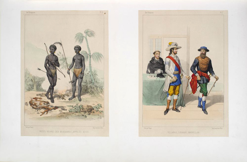
FIRST EDITION OF THE VERY RARE ATLAS of a work of considerable merit tracing the development of the Philippines from its first discovery by Europeans, the geography of its provinces and indigenous people, its civil, military, and ecclesiastical government, industry, commerce and education. It was later plagiarized by Manuel Buzeta and Felipe Bravo for their "Diccionario geográfico" 1851. Mallat himself seems to have followed a similar survey made by Sinibaldo de Mas in his "Informe sobre el estado de las Islas Filipinas" 1843. Much of Mallat's work on this book was done in the Philippines where he was attached to the Hospital de San Juan de Dios in Manila.


- Published
- Paris: Arthus Bertrand, [1836].
- References
- Not in Colas or Lipperheide; Robertson p.134; Bobins 281.
- Plates
- 10
- Binding/Size
- L=FOLIO
- Value
- 0-5000
- Published
- Paris: Arthus Bertrand, [1836].
- Ref
- 5067
Atlas volume only, folio, folding map outlined in colour, ten hand-coloured plates, seven other maps or plans on four leaves, and one folding leaf of music. Contemporary half calf. An unusual series of illustrations of the Philippines, including genre scenes, everyday life, agriculture, industry, commerce, etc. "A work of considerable merit...the atlas accompanying the work is very rare, and we have not seen it" (Robertson). Coloured plates in order: Carte des Isles Philippines (folding). 1. Petits Negres des Montagnes, appeles Actas. 2. Villabos, Legaspi, Magellan. 3. Bisayas Sauvages ou des Montagnes. 4.Indiens Tagales pilant du riz. 5. Indiens Bisayas. 6. Indiens Pampangos. 7. Indiens Yfugaos. 8. Metis de la Haute Classe en promenade. 9. Metis Chinois ou Sangley. 10. Metis Espagnols en costume de promenade.