If you would like to get in touch, please feel free to contact: email hidden; JavaScript is required
Browse collection
- Full collection
- 18th Century & earlier
- Ackermann
- Africa
- Alken
- Animals
- Arabasia
- Architecture/Mansions
- Art
- Australasia
- Botany
- British Isles
- Caricatures
- Children
- China
- Chromo added colour
- Chromolithographs
- Conchology
- Costume
- Cruikshank
- Culture/Lifestyle
- Dutch
- East European
- Far East
- France
- Furniture/Antiques
- General
- Germany
- Grandville
- Heraldry
- History
- History - England
- History - Europe
- Holy Land
- India
- India - sepia
- Islam
- Italy
- Japan
- Literature
- London
- Manuscript
- Map
- Military
- Monnier
- Natural history
- Pastimes
- Pochoir
- Polar regions
- Portraits
- Religious/Christian
- Religious/other
- Rowlandson
- Russia
- Science
- Scrapbook
- Sepia
- South America
- Sports/Hunting
- Stamps
- Swiss
- The Americas
- Theatre
- Travel/Scenery
- Watercolours
- World
JACKSON, Charles Thomas.
First Report on the Geology of the State of Maine.
Charles T. Jackson (1805–1880) was a physician and pioneering geologist and mineralogist who played an important role in the emergent state geological survey movement of his day. While studying at Harvard Medical School he undertook a geological exploration of Nova Scotia, deepening his interest in geology. By 1836, he had abandoned medicine and was appointed state geologist of Maine. Jackson’s three reports on the geology of the state were published in 1837, 1838, and 1839. Subsequently, he served as a state geologist of Rhode Island and New Hampshire.


- Published
- Augusta: Smith and Robinson, 1837.
- Plates
- 21
- Binding/Size
- S=8vo
- Value
- 0-5000
- Published
- Augusta: Smith and Robinson, 1837.
- Ref
- 1287
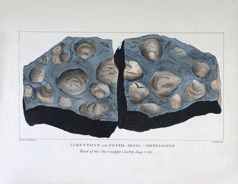
2 volumes: Oblong Atlas volume containing 21 hand-coloured lithographs, three black and white lithographs; text volume in small 4to, pp. 127, (1) being List of Plates (in the Atlas) accompanying this Report. Atlas with original grey boards and paper title label to upper, recent burgundy corners and spine with titles in gilt. Text volume recently bound to match. Atlas boards a little rubbed, its original title label with two minor chips; unobtrusive blind stamp to upper corner of the first black and white plate; faint toning to verso of plates, colouring bright. Text volume with occasional light browning. In all, a superior copy. RARE. Only one complete copy at auction in the past 35 years. Coloured plates in order: 1. Limestone with Fossil Shell Impressions. 2. Brecciate Green Marble & Red Sandstone. 3. Grand Falls of the River St. John. 4. Mount Ktaadn from W.Butterfield's (1836) near the Grand Schoodic Lake. 5. View down St. Croix River with The Devil's head from above the Ledge. 6. Breccia Liberty Point, Robbinston. 7. Red Sandstone, Pulpit Rock. Perry bearing N.W. 8. Pulpit Rock near Lewis Cove, Perry ME. View from the East, Aug 1836. 9. Trap-Dyke in New Red Sandstone, Friendship's Folly Island near L'Etang N.B. 10. View of Lubec & Campo-Bello from Eastport, ME. 11. Greenstone Trap. Old Friar's Head, Campobello, bearing East, Oct 1836. 12. Disposition of Slate & Greenstone Trap-Rocks. West Quoddy-Head. 13. West Quoddy Head Lighthouse. 14. Point of Maine, exhibiting the disposition of Red Sandstone, Limestone, and Greenstone Trap. 15. Greenstone Trap-Dyke, intersecting the Porphyry, at Yellow Head Island, off Bucks Harbour. 16. Variegated Marble, Red Sandstone & Trap Rocks. Starboard's Creek, near Machias. 17. Mount Desert, bearing N.W. 10 miles. 18. Granite Mountains in Mount Desert. 19. Cape Rosier, Talcose & Micagrous Slate. 20. View of Camden & the Penobscot Bay, from the Megunticook. 21. Megunticook Mountain & entrance to Camden Harbour.