If you would like to get in touch, please feel free to contact: email hidden; JavaScript is required
Browse collection
- Full collection
- 18th Century & earlier
- Ackermann
- Africa
- Alken
- Animals
- Arabasia
- Architecture/Mansions
- Art
- Australasia
- Botany
- British Isles
- Caricatures
- Children
- China
- Chromo added colour
- Chromolithographs
- Conchology
- Costume
- Cruikshank
- Culture/Lifestyle
- Dutch
- East European
- Far East
- France
- Furniture/Antiques
- General
- Germany
- Grandville
- Heraldry
- History
- History - England
- History - Europe
- Holy Land
- India
- India - sepia
- Islam
- Italy
- Japan
- Literature
- London
- Manuscript
- Map
- Military
- Monnier
- Natural history
- Pastimes
- Pochoir
- Polar regions
- Portraits
- Religious/Christian
- Religious/other
- Rowlandson
- Russia
- Science
- Scrapbook
- Sepia
- South America
- Sports/Hunting
- Stamps
- Swiss
- The Americas
- Theatre
- Travel/Scenery
- Watercolours
- World
GRAAH, Wilhelm August.
Undersogelses-Reise til Ostkysten af Gronland. Efter Kongelig Befalning udfort i Aarene.
Report by the Danish naval officer WA Graah (1793-1863) on his carried out expedition on the orders of King Christian VIII with the brig "Halfisken" to explore the uninhabited east coast of Greenland, during which the geologist Christian Pingel and the botanist Jens Vahl.


- Published
- Kobenhavn: J.D. Quist, 1832.
- References
- Bobins II 404; Sabin 28178.
- Plates
- 8
- Binding/Size
- M=4to
- Value
- 0-5000
- Published
- Kobenhavn: J.D. Quist, 1832.
- Ref
- 983
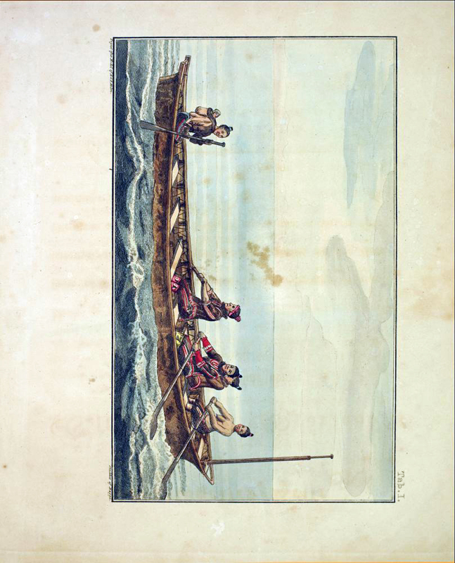
[Diving Trip to the East Coast of Greenland.] FIRST EDITION. 4to, pp. xvii, [1], 216; 8 hand-coloured lithographs; large folding map (approx. 35" x 26 1/2") based on the best information of the author, Egede, Parry, Scorsby, Ross, etc., showing the coast of Labrador and Baffin Island in the west, east to Iceland. Includes an elaborate map (the best of its day) of the west coast of Greenland, as far north as Upernavik and as far as what is now Andree's Land in the east. The map may not be present in all copies. Title-page and the first page of introduction reinserted, title-page mis-creased and with an odd cropping at the bottom margin, occasional paper repairs, edges rubbed, some wear at spine extremities, some offset to plates, and some foxing throughout - otherwise, this is a good, sound copy. Contemporary calf-backed marbled boards, gilt lettering, and decorative 'Greek Key' design to spine. In 1829-30 a Danish expedition led by W.A Graah traveled along the coast from Cape Farewell, the southernmost point of Greenland, to the southwestern part of Ammassalik District. It contains the author's diary of his sojourns at Julianaehaab and Nennortalik, his investigations of the Norse ruins at Kakortok in West Greenland; his notes of a trip in an umiak along the southeast coast of Greenland; his wintering at Nukarbik; his unsuccessful attempt to continue further north; as well as observations on the climate, temperatures, ice conditions, geography, etc., etc. Printed in Danish. Plates are not captioned. An English edition was published in 1837. Coloured plates in order: 1. Frontispiece. Greenlander people travel in a large canoe. 2. Hunter, armed with a harpoon, at sea, in his canoe. 3-5. Ruins of assorted brick buildings. 6. Greenlander tent, with fire and provisions, etc. 7. Interior of a Greenlander tent with three inhabitants inside. 8. Various Greenlander artifacts (5 figs)